Tuesday, July 8, 2014

Mt. Evans, again . . . July 6, 2014

After a long day of climbing on Saturday, I was convinced to ride Mt. Evans again on Sunday.  This time I rode with Brian Patty from work.  After my description of the ride from the weekend before, he decided he really wanted to do this climb.  I wanted to get in another good ride, so I decided I could give it another shot.

I already explained the entire route in my description of last weekend's ride, so I won't go into the whole thing again.  It's the same ride.

The weather was probably about 10 degrees warmer, which at the summit is still pretty damn cold.  Brian did great, beating me to the summit by a couple minutes.  But he kept riding while I stopped for a bathroom break at Summit Lake, and I just couldn't catch back up to him.

Just like the previous weekend, I was getting disheartened toward the end.  Once you make that turn and finally see the summit, it just looks so far away.  The only thing that really kept me going this time was the fact that Brian was up ahead and I didn't have a way to tell him I wanted to turn around.  Closer to the summit, we were on adjacent switchbacks, and he was actually directly above me on the road.  We stopped, and I yelled up to him that I thought I might turn around, and not to wait for me.  I had already been to the summit, so doing it again wasn't really going to prove anything.  But after resting for a couple minutes, and getting some food and water, I hopped on the bike and just kept slowly pedaling.  I'm not sure why I kept going up instead of down, but that's what happened, and I made it to the parking lot a short time later.

This time, although the climb itself was the same, I was a little better prepared.  I had brought my wind vest, long-finger gloves and shoe covers, all of which I left at home the previous weekend.  I was definitely thankful I had them this time.  Although the ride back down certainly wasn't "enjoyable", at least it was a little more tolerable.  I still think that downhill is ridiculous and dangerous, and I have no desire to do it again any time soon.

That was certainly a long weekend of climbing, and I decided I'd skip the bike-commute to work on Monday and just take my car.  My legs and butt could use the break.

Near the Mt. Goliath Natural Area, looking down on Echo Lake.  Just above treeline.


At the summit parking lot.


Kerr Gulch - Squaw Pass, July 5, 2014

On July 4 weekend, I wanted to take the opportunity to get in some long rides.  It looked like some people from my team were going to be out riding, but I decided to try to get in some riding with some friends from work instead.  So, I sent out an email on Thursday to see if anyone was interested, but only got a couple responses.  A structural engineer that I work with was hoping to do a ride on Saturday, and a coworker wanted to ride on Sunday.  I decided to do both.

On Saturday, I met Heath Stein from Structural Consultants, Inc,. in Morrison, Colorado for a long climb up some of the roads in his neck of the woods.  We would be riding from Morrison, Colorado up to Squaw Pass, near the entrance station to Mt. Evans.  About 30 miles uphill, and 30 miles back down, with about 6,000 feet of climbing.  Heath lives nearby in Lakewood, and rode his bike to the parking lot where we decided to meet.  My day started off on a low note, as I dropped my phone while getting out of the car, shattering the screen.  But once we were riding, I forgot all about it.

The ride started up Bear Creek Canyon.  The road was a little busy, with limited shoulder.  So, it was single-file for a few miles.  We then took a right, and headed up Kerr Gulch.  This was a great road.  After about a half-mile of rougher asphalt, the road smoothed out and became a great quiet ride for miles and miles.  After a final steep climb up towards Evergreen, we took a left and followed Evergreen Parkway for about a mile or so.  This road is very busy, but there is a wide shoulder most of the way.  Then, a right turn takes us onto Squaw Pass Road for the rest of the climb.

Squaw Pass Road is fantastic.  I really can't wait to ride it again.  The road is smooth, with a big, fat bike lane the entire way up.  Everyone else seems to know this, too, because there are a lot of bikes on the road.  This seems to be a very popular route.

The view along Squaw Pass Road.


About 2 miles from the top of Squaw Pass, Heath got a flat tire.  We stopped for a few minutes to put on a new tube, and then finished our climb.

We then turned around, and headed back down on one of the most enjoyable downhills I've ever done.  It's a steady grade, not too steep, and the turns are mostly pretty wide.  You really don't have to pedal or hit your brakes.  Even better, the entire downhill is marked as "Bicycles have use of entire lane".  Awesome.  We quickly made it back down to Evergreen, and then onto Kerr Gulch.  From there, we rode down to Bear Creek Canyon for the homestretch.  Unfortunately, about 2 miles from the finish, I hit a rock and got a flat tire.  After a little break to patch a tube, we finished the ride and got back to my car.

I felt amazingly good after that much climbing.  I'm not sure how ready I was going to be for another tough ride the next day, though.  Sounds like I was a little better than Heath, though, who later told me he crashed on his couch when he got home.


My son's first mountain bike ride - Teller Lake Trail, June 29, 2014

My kids have been riding bikes since they were about 3 years old or so.  We typically just ride around the neighborhood or occasionally ride on the Platte River Trail.  My son asked me "Dad?  Do I have a mountain bike?"  He really didn't know.  I told him it was a mountain bike.  A few days later, he told me he wanted to go mountain biking.  It must have occurred to him that since he had a mountain bike, he should go mountain biking.

I told him I'd love to take him mountain biking, but I needed to find a good trail.  I pulled out Mountain Biking Denver and Boulder, which I hadn't looked at in years, and started browsing for easy rides.  And I actually ended up with a ride I'd already done a few years ago.  There were a few other decent options in the book, but they all seemed to require paying for parking, which was annoying.

I decided to ride the Teller Lake Trail, which starts just off Arapahoe Road in Boulder.  The first half of the ride is basically flat packed gravel, and the second half is a combination of single-track and double-track with some moderate hills.  With this being my son's first time off-pavement, I thought we could at least ride the flat easy stuff, then ride the single- and double-track until he got tired, and then we could just turn around and go back.  The overall out-and-back distance is 12.2 miles, which is pretty close to the farthest he's ever ridden.

We covered the first part of the trail easily, stopping to pet some horses and talk to some cows.  After crossing Valmont Rd., the trail becomes single track.  He handled the narrower trail just fine.  Then we hit a tricky spot, somewhat unexpectedly.  I've ridden this trail a few times before, but it's been a while.  We came across a stream crossing that I don't think is supposed to be there.  I believe this is new, a result of a massive flooding back in September 2013.  There is actually a bridge over a stream just down the trail, but it appears a pond broke through its banks and created this second crossing.  The water wasn't deep, but the bottom was covered in loose rocks.  I went first, so I could turn around and get a photo of him crossing.  I made it through, although it was a little sketchy.  He followed, but only made it about halfway across before he had to stop and walk.  His shoes got wet, but otherwise he was fine.  We soldiered on.

Shortly after this, we hit the first of our hills and some fun single-track.  He is finally starting to understand the gears on his bike, and how to shift, and why.  He got into his lowest gear and made his way up the hill really well.  He had to stop once in a while, but after taking a break to catch his breath, he got right back on and kept pedaling.  What a trooper.  The trail continued on like this for a while, a couple ups and a couple downs, through single- and double-track, until the last climb up to the water tower at the top of the trail.  We took a little snack and drink break, then turned around and headed back the way we came.

I'm really proud of him!  He did awesome, way better than I expected.  I knew he could do it, but I just thought his brain might call it quits before his legs did.  But he pushed on, and made it the whole way, like a champ.  He loved it, and now I need to look around for more trails for us to do.

Here is a collection of photos from the day:

A few horses near the beginning of the trail.

Lookin' cool.


Stream crossing.

A little bit of uphill.


Monday, July 7, 2014

Mt. Evans - June 28, 2014

On June 28, Josh from my team decided to do a training ride up Mt. Evans, to help get ready for the Bob Cook Memorial Mt. Evans Hill Climb.  The race is on July 26, and I'll be on vacation at the time, so I won't be able to participate.  But I've always wanted to climb Mt. Evans anyway, so I decided to go.

Mt. Evans is one of Colorado's fourteeners, mountains with summits over 14,000 in altitude.  I used to think there were 54 of them in Colorado, but recently heard there are 58.  I guess it depends on how they are counted.  Anyway, the Mt. Evans road also happens to be the highest paved road in the United States.  The road extends to a small parking lot just below the 14,130' summit.  I'd driven the road a few times before, since it's a popular spot to take visitors to Colorado, but I'd never hiked or biked to the summit.

We started our ride in Idaho Springs, just off I-70 at about 7,500'.  Although it was supposed to be a "team" ride, the only Zillas attending were me and Josh.  We also had a couple other racers along for the ride, Michael (Cat 4) and Tyler (Cat 3).

We headed out from the parking lot at about 8:30am to begin the long slog to the summit.  The route to the summit is about 28 miles, basically all uphill.  There are a couple very short sections of downhill, but not much.  The first 6 or 7 miles has a pretty steady grade of about 2-3%.  Past that, the grade increases to about 4-6% for the rest of the ride.

About 13 miles in, you come to Echo Lake and then the Mt. Evans entrance station, at about elevation 10,750'.  After passing through the entrance station, you climb a little more to the Mt. Goliath Natural Area, where you can walk among 1,000 bristlecone pines.  The hardy trees exist right at treeline, the boundary between the forest below and tundra above.  After passing through this area, you then make a left turn and come face-to-face with the beauty of the Colorado mountains.  Unfortunately, you also come face-to-face with the wind.  From here until the summit, you are above treeline and exposed to sun, wind, rain, hail, or whatever Mother Nature wants to throw at you.  It's amazing the difference that one left turn can make.

At this point, Josh started to feel kind of crappy.  The altitude was getting to him, and he just didn't have the strength to go on.  Michael and Tyler had already ridden ahead, so I chatted with Josh for a few minutes, and he said he was turning around.  We told each other to be safe, and I went on ahead while he turned around and started to head back down.

Josh, just before turning around for the day.  He's giving me a thumb's up, but I don't think he really means it.


The great views you get once you're above treeline.


After riding a few more miles, and enjoying the great views in every direction, you finally get a nice little downhill to Summit Lake.  Then it's time to go up again.  It's really not that much further to the summit, but by this time, the altitude really starts to take its toll, and it's a long slog to the finish.  After a couple miles, you make a left turn and the summit finally comes into view in the distance, and it just seems so far away.  It's really disheartening to see how much further you still have to go.  The observatory at the summit just sits there taunting you for the rest of the ride.  Maybe some people will look at it and it will help them drive to the finish.  But to me, it just makes you think about how much climbing you have left to go.

End of June, and still some really deep snow up here.


The altitude was really starting to get to me, and I started to think I couldn't do it.  I was cold and hungry, and just didn't know if I had the energy to get to the top.  But I was so close.  I stopped to take a couple breaks, eating and drinking, and giving my legs a break.  There are a bunch of tight switchbacks just before the summit, and I had to ride into a strong headwind.  Even when the wind was blasting me as I tried to climb, I talked myself into pushing ahead, knowing that when I turned up ahead, I would have a strong tailwind.  That really kept me going, looking forward to the upcoming tailwind.  A little below the summit, I ran into Michael and Tyler on their way down.  They had gotten to the summit parking lot, stuck around for about a minute, and turned right around.  They were both really cold, and just wanted to get back down the mountain.  I told them I was going to get myself to the summit, and would see them back in town soon.


After a couple more switchbacks, I finally got to the parking lot.  Then, even though I was cold and tired, I decided that there was no way I was riding this far and not actually going to the summit.  From the parking lot, it's about a 5-minute walk up a bunch of rocks to get to the actual summit of Mt. Evans.  I put on my wind/rain jacket, put some rubber cleat covers on my shoes, and started walking.  I hung around the summit for a couple minutes to take some pictures, then headed back down to my bike.

14,116 feet.  7,094' of elevation gain to the parking lot.  Ignore that temperature reading.  That thing has never worked right from the day I got this computer.


View from the summit.


USGS marker on the summit.

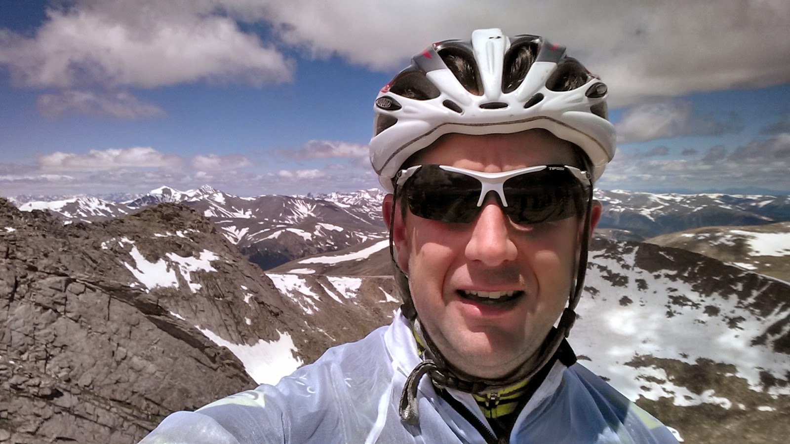
Happy to be done climbing for the day.


Usually, after a long, long climb, the downhill makes up for all the pain of ascending.  That's not really true for Mt. Evans.  The descent off Mt. Evans is miserable.  The road is in terrible shape.  There are cracks, bumps and potholes everywhere.  Going up, you're going so slow that you don't even notice.  But on the way down, at high speed and a cold, tired body, you feel every bump.  The edge of the road just kind of falls away down the mountain, and there are some enormous potholes that could just swallow a bike.  Truthfully, I think it's really dangerous, and I was very uncomfortable and nervous for most of the descent.  The wind was terrible, the temperature was about 30-35 degrees at the summit, and I didn't have much in the way of warm clothes.  I could barely feel my fingers, and every bump in the road seemed to rattle my entire body.  I was swearing to myself pretty much the entire descent.

Back down at the entrance station, the weather is warmer, and the road is smooth all the way back to Idaho Springs.  Unfortunately, by that time, I was so miserable, I couldn't even enjoy it.  I just wanted to be done.

I got back to the car, changed my clothes and texted the guys to find out where they were.  They were already sitting down at the Main Street Restaurant.  I headed over to relax with some food and beer.  The best way to end a tough ride.